Q. 41: Why do you conclude that the Sierra batholith must have been molten during the Flood?
CPT Q. #41 – 101 Q&A on Catastrophic Plate Tectonics
Question: 41. Why do you conclude that the Sierra batholith must have been molten during the Flood?
Response: Geological investigations of the rocks of the Sierra Nevada over the past fifty years [ed. — i.e., since the mid-20th century] have revealed that the granitic rocks that form what is called the Sierra Nevada Batholith crystallized a few kilometers beneath the surface from molten magma that had risen from below and had ponded as hundreds to thousands of individual pancake-shaped plutons at the shallower depths. Careful and extensive radioisotope dating indicates these plutons were emplaced during the Mesozoic, mostly during the Cretaceous, which implies that the melting and cooling took place during the Flood.
Let me quote the beginning three paragraphs from an article entitled, “The Sierra Nevada Batholith as exposed in the Yosemite Valley area and western foothills of the Sierra Nevada,” by Marty Giaramita from California State University, Stanislaus, which provides a good summary description of the rocks of the Sierra Nevada Batholith in the region around Yosemite National Park:
The terrane of Yosemite National Park is characterized by abundant light-colored and less common dark-colored rocks that crystallized slowly from molten rock kilometers beneath the Earth’s surface. The present exposure of these relatively coarse-grained rocks is the result of uplift and removal of the overlying rock by erosive agents such as rivers and glaciers long after their intrusion into the crust due to tectonic-plate conversion during Mesozoic time.
Igneous rocks are those that crystallized from melt. They are broadly subdivided into volcanic (extrusive) rocks, if they were erupted on the surface and hence rapidly cooled, and plutonic (intrusive) rocks, if they crystallized slowly at depth beneath the Earth’s surface and cooled slowly. Although volcanic rocks are present in the Sierra Nevada Mountains (and we will drive through some en route to Yosemite), the predominant rock type in the region of Yosemite National Park is plutonic. Exposed bodies of plutonic rock are referred to as plutons that are further subdivided on the basis of their shape. A stock is a roughly equidimensional pluton; a dike is a fracture filled with plutonic rock. A batholith is a large composite of many individual plutons.
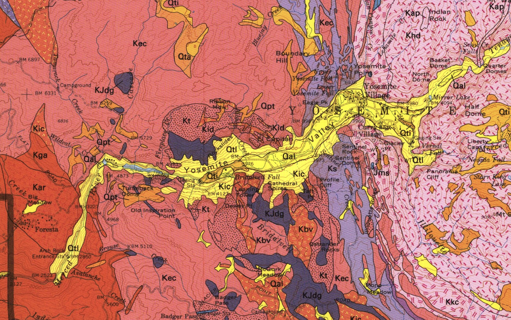
The intrusive rocks of the Yosemite Region are part of the Sierra Nevada Batholith consisting of hundreds of individual plutons intruded from the Triassic through the Cretaceous periods (See the geologic map of Yosemite Valley below). Most geologists now agree that the batholith owes its existence to the process of tectonic-plate convergence during which melting occurred as a consequence of subduction of oceanic lithosphere (the rigid crust and upper part of the mantle) beneath the margin of the North American continent during Mesozoic time. A present-day analogue for this process is the subduction of the Nazca oceanic plate beneath the western margin of the South American continent.
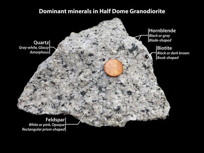
Below is a photo of some granitic rock typical of that which comprises the entire batholith:
Below is a geological map of the Yosemite area that shows the extent of the individual plutons which can be distinguished by their distinctive chemical compositions and mineralogies. Most of these plutonic rocks are of Cretaceous (K) age. Most of the Quaternary (Q) rocks are associated with the glacial processes of the Ice Age. This map provides a representative sampling of the geological character of the entire batholith.
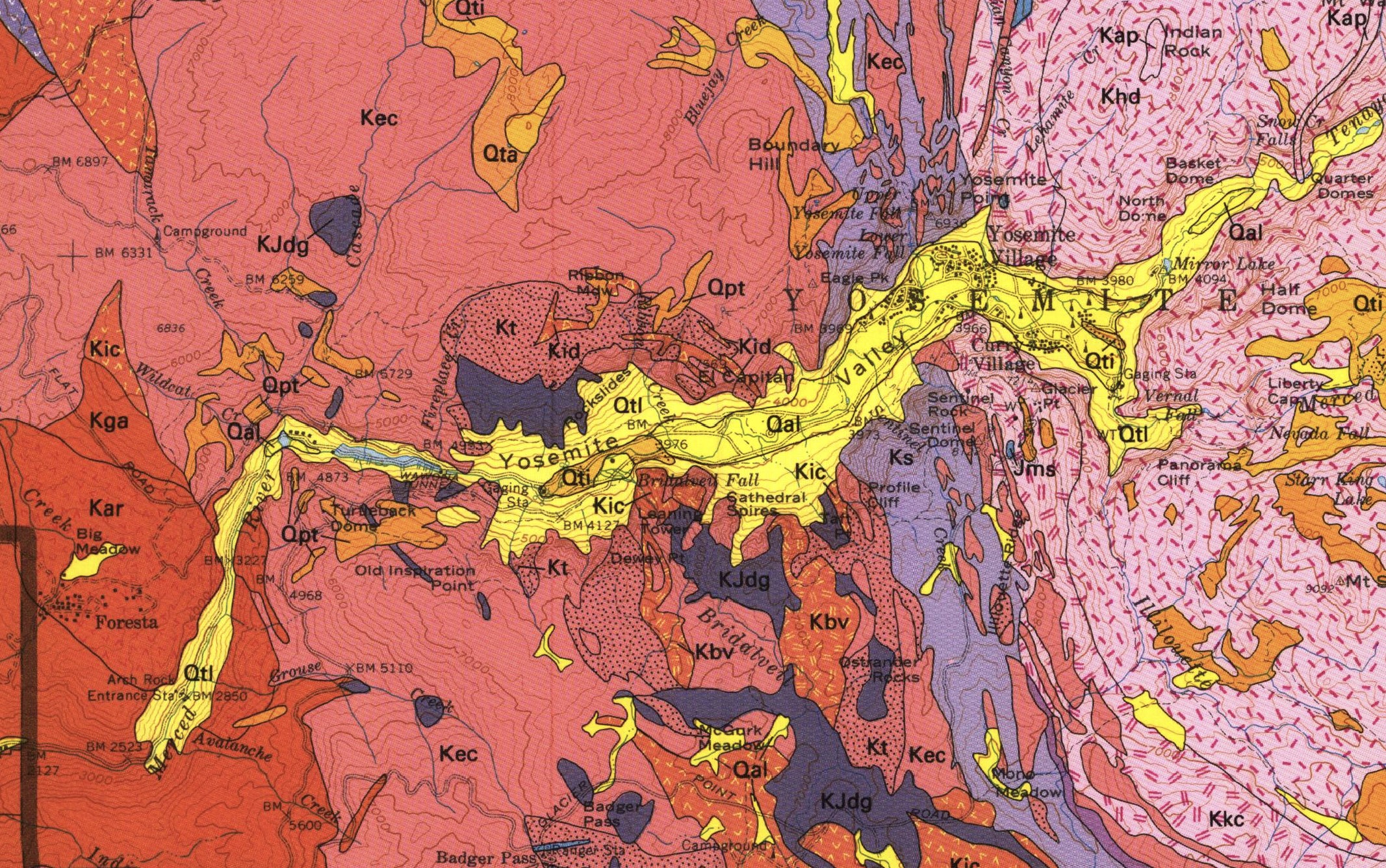
Explanation of Symbols
- Qal: Quaternary Alluvium Includes stream deposits, meadow deposits, and glacial outwash. (Quaternary)
- Qtl: Talus Rock waste derived from cliffs. Only especially extensive areas shown. (Holocene)
- Qti: Tioga Till Moraines usually sharp crested with abundant boulders at surface. (Pleistocene)
- Qta: Tahoe Till Moraines usually crested, but subdued, with scattered, weathered boulders at surface. (Pleistocene)
- Qpt: Pre-Tahoe Till Moraines hummocky and dissected. May include Sherwin tills. (Pleistocene)
- Khd: Half Dome Granodiorite Medium grained biotite hornblende granodiorite with conspicuous crystals of sphene. Locally porphyritic with abundant large phenocrysts of potassium feldspar. Age 86-88 Ma
- Kkc: Granodiorite of Kuna Crest Dark-colored, fine- to medium-grained, biotite-hornblende granodiorite. Age 88 Ma
- Ks: Sentinel Granodiorite Coarse-grained, dark-gray, biotite-hornblende granodiorite with abundant sphene. Age 93 Ma
- Kbv: Bridalveil Granodiorite Fine-grained hornblende-biotite granodiorite and granite.
- Kic: Granodiorite of Illilouette Creek Medium- to coarse-grained mafic hornblende-biotite granodiorite, tonalite and granite. Age about 100 Ma
- Kid: Quartz Diorite Dark fine-grained rock rich in hornblende. Occurs as irregular intrusive masses cross-cutting El Capitan and Taft Granites on north side of Yosemite Valley.
- Kt: Taft Granite Fine- to coarse-grained white to gray biotite granite and biotite granodiorite. Locally porphyritic with phenocrysts of potassium feldspar. Age 96 Ma
- Kec: El Capitan Granite Coarse-grained, white to light-gray biotite granite and biotite granodiorite. Commonly porphyritic with blocky phenocrysts of potassium feldspar and conspicuous quartz grains. Age about 102 Ma
- Kga: Tonalite of the Gateway Also known as Bass Lake Tonalite. Medium-grained biotite-hornblende tonalite. Varies to granodiorite and quartz diorite. Age 114 Ma
- Kar: Granodiorite of Arch Rock Medium-grained, biotite granodiorite, commonly with poikilitic potassium feldspar. Age 116 Ma
- KJdg: Diorite and Gabbro Occurs as generally small, irregularly shaped bodies throughout map area, including the Rockslides adjacent to El Capitan. Age Jurassic to Cretaceous
- Jms: Metasedimentary rock Hornfels and other metamorphic rocks. Jurassic
The massive volume of granitic magma was generated via subduction of the Farallon Plate beneath the western edge of North America and likely involved the melting of a significant volume of sediments entrained by the subducting slab. As I noted in my answer to question 30:
The belt of Mesozoic-Tertiary plutonic rocks extending from Alaska to Antarctica, forming much of the mountain belt known as the American Cordillera, was produced by this subduction-caused melting beneath the western margins of these continents. The maps below display the main sites of this plutonic emplacement of new crustal material. Isostatic adjustment in these belts has resulted in the mountains we see there today.
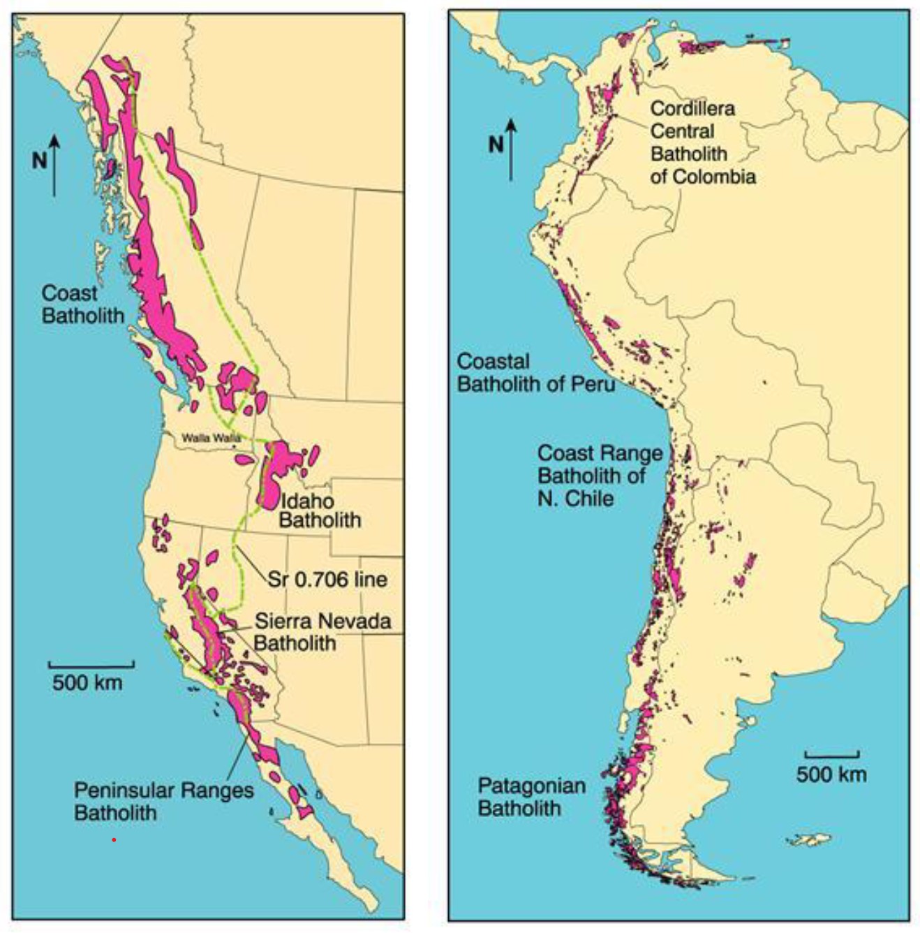


Let me here emphasize that not only was the Sierra Nevada Batholith generated by upwelling granitic magma during the Flood, but all the batholiths shown in the figure above were produced by the same subduction-driven process during the Flood.
Footnotes
J. D. Winter, An Introduction to Igneous and Metamorphic Petrology, Prentice Hall, 2001.↩︎