Q. 89: Is there convincing observational evidence for flow in the mantle today?
CPT Q. #89 – 101 Q&A on Catastrophic Plate Tectonics
Question: 89. What solid evidence, if any, do you feel exists for the presence of flow in the mantle?
Response: There are two lines of evidence which seem particularly convincing to me. First are the GPS measurements that show motions at plate boundaries across the earth which are highly consistent with plate tectonics expectations. The noise levels in these measurements are now so small that to me the values are beyond dispute.
I described these measurements in my answer to question 7, but let me reproduce the NASA figure which summarizes these results again for convenience. These results exploit the constellation of 24 Global Positioning System (GPS) satellites. Daily position estimates are determined and recorded for each of more than 900 GPS receivers on the ground from the satellite signals. Data from these stations were processed and analyzed at the Jet Propulsion Laboratory, California Institute of Technology under contract with the National Aeronautics and Space Administration. Horizontal velocities, mostly due to motion of the Earth’s tectonic plates and deformation in plate boundary zones, are represented on the maps by arrows extending from each of the more than 900 receiver stations shown in the map below.
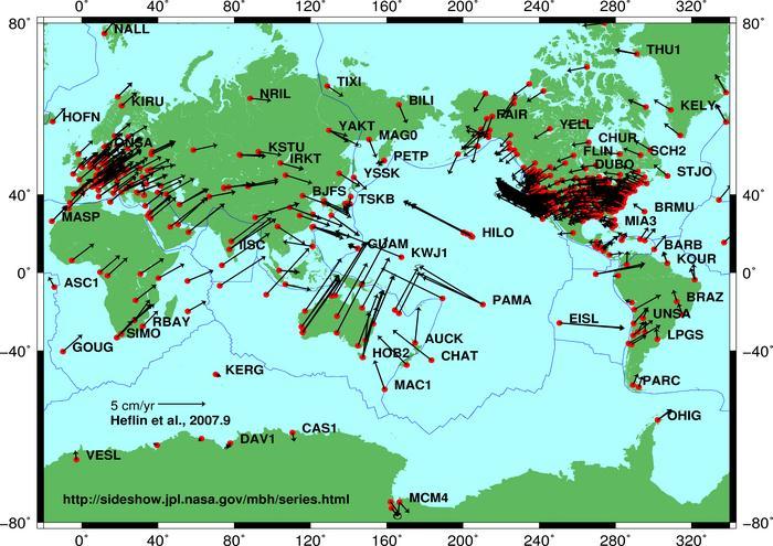
Notice especially the large velocity of the Pacific Plate, the high rate of convergence (via subduction) in the western Pacific, the high rate of convergence of the Australian Plate with the plates to the north (also via subduction), and the high rate of divergence (via seafloor spreading) along the East Pacific Rise. These surface motions, observable in the present day, imply motions of similar magnitude in the mantle beneath. What are the forces available to drive these surface motions? The primary one is gravity acting on the negative buoyancy of the cold subducted rock currently present in the mantle. These data to me represent persuasive evidence that flow indeed is taking place within the mantle of the earth.
A second related line of evidence concerns the displacements which accompany earthquakes around the earth. With the large numbers of seismic stations around the world today it is possible to process the seismic signals for most earthquakes of at least modest size to recover the orientation of the fault and the direction of motion responsible for the earthquake. Let us consider some recent examples of large earthquakes. The magnitude 8.8 megathrust earthquake that occurred on February 27, 2010 just off the Chilean coast involved the thrusting of the oceanic Nazca Plate beneath the South American Plate, consistent with subduction occurring along the western margin of South America. The Wikipedia article on this earthquake states:
The segment of the fault zone which ruptured in this earthquake was estimated to be over 700 km (430 mi) long with a displacement of almost 10 meters. It lay immediately north of the 1,000 km (620 mi) segment which ruptured in the great earthquake of 1960. Preliminary measurements show that the entire South American Plate moved abruptly westward during the quake. A research collaborative of Ohio State and other institutions have found, using GPS, that the earthquake shifted Santiago 11 inches (28 cm) to the west-southwest and moved Concepción at least 10 feet (at least 3 meters) to the west. The earthquake also shifted other parts of South America from the Falkland Islands to Fortaleza, Brazil. For example, it moved Argentina’s capital of Buenos Aires about one inch (2.5 cm) to the west. Several cities south of Cobquecura were also raised, by up to 3 meters.
Another huge megathrust earthquake occurred on December 26, 2004, off the west coast of Sumatra. This 9.1 magnitude earthquake was caused by underthrusting of the India-Australia Plate beneath the Burma Plate. It triggered a series of devastating tsunamis along the coasts of most landmasses bordering the Indian Ocean, killing over 230,000 people in fourteen countries, and inundating coastal communities with waves up to 30 meters (100 feet) high. It was one of the deadliest natural disasters in recorded history. It is consistent with subduction along the Sumatra Trench. In regard to the mechanics of the earthquake, the Wikipedia article states:
An estimated 1,600 km (994 mi) of fault surface slipped (or ruptured) about 15 m (50 ft) along the subduction zone where the India Plate slides (or subducts) under the overriding Burma Plate. The slip did not happen instantaneously but took place in two phases over a period of several minutes:
Seismographic and acoustic data indicate that the first phase involved a rupture about 400 km (250 mi) long and 100 km (60 mi) wide, located 30 km (19 mi) beneath the sea bed—the largest rupture ever known to have been caused by an earthquake. The rupture proceeded at a speed of about 2.8 km/s (1.7 mi/s) or 10,000 km/h (6,300 mph), beginning off the coast of Aceh and proceeding north-westerly over a period of about 100 seconds.
A pause of about another 100 seconds took place before the rupture continued northwards towards the Andaman and Nicobar Islands. However, the northern rupture occurred more slowly than in the south, at about 2.1 km/s (1.3 mi/s) or 7,600 km/h (4,700 mph), continuing north for another five minutes to a plate boundary where the fault type changes from subduction to strike-slip (the two plates slide past one another in opposite directions). This reduced the speed of the water displacement and so reducing the size of the tsunami that hit the northern part of the Indian Ocean.
Another megathrust earthquake occurred on March 27, 1964 near Anchorage, Alaska. Lasting nearly five minutes, this 9.2 magnitude event was the most powerful recorded earthquake in North American history and the second most powerful ever measured by seismograph anywhere in the world. Across south-central Alaska, ground fissures, collapsing buildings, and tsunamis directly caused about 131 deaths. This earthquake was caused by the rapid underthrusting of the Pacific Plate beneath the North American Plate near College Fjord in Prince William Sound, 78 miles (125 km) east of Anchorage and 40 miles (64 km) west of Valdez.
The purpose in citing these examples is to point out that earthquakes in general yield displacements which are in overwhelming accord with the plate motions provided by GPS measurements. These active displacements represent yet another line of observational support for the conclusion that plate motions are truly taking place across the earth’s surface today. Motions in the mantle’s top boundary layer mean that motions of similar magnitude are occurring within the volume beneath.