Q. 95: What actual evidence exists for the opening and closing of the Iapetus Ocean?
CPT Q. #95 – 101 Q&A on Catastrophic Plate Tectonics
Question: 95. Could you please provide a short summary of the evidence and references as to why you think, as you said in your answer to question 47, “the observational evidence for the opening and closing of the Iapetus Ocean and the associated tectonic signature in the continental rock record, including the Appalachian orogeny, is close to indisputable.” You also characterized the evidence as strong in your response to question 24 relative to the continental movements depicted in Blakey’s maps, though maintaining these movements happened in a much shorter time frame than is conventionally held.
Response: One reference I have on my shelf is the textbook by R. Dott, Jr., and R. Batten entitled Evolution of the Earth, 2nd Ed., published by McGraw Hill in 1976. What I will do here is to select a few figures from this book to give you what has to be only a sampling of the field work of hundreds to thousands of geologists over the preceding century to assemble the beginnings of a coherent picture of the physical rock record in the North Atlantic part of the world. Granted that most of these geologists had a uniformitarian outlook, the overall sequence of events they have inferred from the relationships of the various rock units to one another seems to be generally correct. It is primarily the time scale which they have assumed that is the problematic issue.
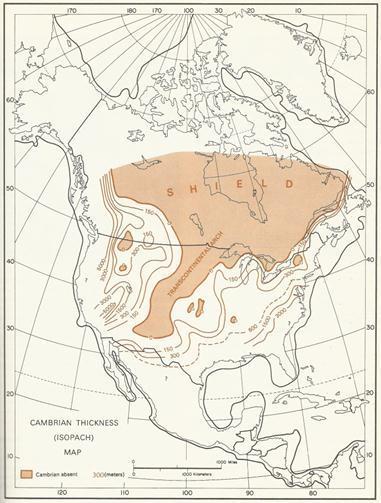
With that important caveat in view, let me attempt to provide a big picture summary. First, let us consider what the rock record seems to indicate about the geography during the early part of the Flood cataclysm. The figure below, Figure 11.19 from Dott and Batten’s book, shows the thickness of only the Cambrian sediments over North America. Note that the sediment thickness tends to increase sharply as one approaches the margins of the craton. Also note the highland areas in much of what is today Canada and also along what is known as the Transcontinental Arch that trends south-southwest from what is now Minnesota toward Arizona. For the purposes of the following discussion, note especially that the sediment distribution implies that ocean lies off what is now the U.S. East Coast.
What does the subsequent part of the rock record in this part of the world indicate about the tectonic processes that were unfolding at the same time? The two figures below, also taken from Dott and Batten’s book, provide a summary picture. The left hand figure provides snapshots of the rock record off the U.S. East Coast at four successive points from what would be early in the Flood until the formation of Pangea. In the first snapshot (A), we observe what corresponds to an oceanic passive margin, with sediments thickening as one approaches the edge of the craton. Then in the Ordovician, the rock sequence begins to record tectonic disturbance migrating westward from the eastern edge of the craton (B).
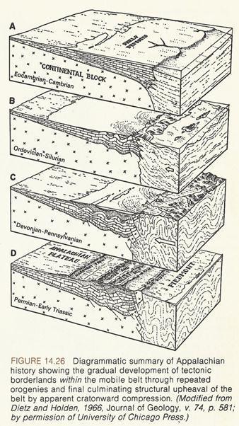
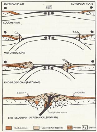
Figure 13.37 from Dott and Batten shows the tectonic regime inferred from the rock records of North American and Europe during this time interval. It shows the sort of highland area inferred for the Late Ordovician based on the types of igneous and metamorphic rocks shed from it. It also shows the symmetry of the rock records in North America and Europe in the spectacular Devonian Acadian-Caledonian Orogeny.
Sediment now begins to be shed toward the west from a new highland area where ocean had previously existed. Then in the Devonian a major pulse of further tectonic deformation occurs which results in huge volumes of sediments eroded from an eastern highland filling basins to the west (C). This Late Devonian pulse is known as the Acadian Orogeny, and what is known as the Catskill clastic wedge in eastern Pennsylvania and New York is sediment derived from the Acadian mountains, as will be described in more detail in subsequent figures. By the time that Pangea is assembled (D), the high topography has been largely beveled away.
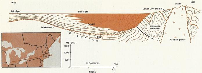
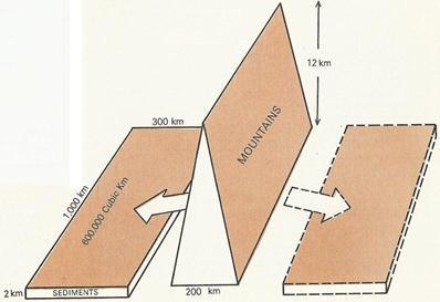
The following two figures, Figure 13.30 and Figure 13.33 from Dott and Batten, highlight the immense volume of Devonian sediments eroded westward from the Acadian mountain range. Especially prominent is the Catskill wedge, chiefly composed of metamorphic and granitic rock fragments, feldspar, mica, and quartz. Its striking red color in the eastern part of the deposit is a result of a small amount of iron oxide between the grains. The volume of the Catskill sediments is about 600,000 cubic kilometers. Assuming an equal volume of sediment was shed to the east (and there is good evidence in Europe that this was indeed the case) this sediment volume requires the erosion of a mountainous mass 1000 km long, 200 km wide, and 12 km high, which is 7 km higher than Mt. Everest. Because erosion likely accompanied the uplift, the mountains likely were never this tall.
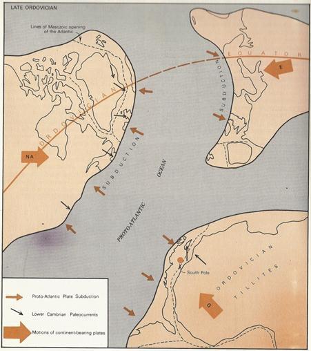
The next figure, Figure 12.31 from Dott and Batten, is a schematic paleogeographic map showing the subduction of the Iapetus (or Proto-Atlantic) Ocean as North America (NA), Europe (E), and Gondwana (G) began their mutual approach in the Ordovician. All that remains of the Iapetus today are mafic oceanic igneous rocks and deep-sea sediments found within the old tectonic belts on either side of the present Atlantic. Note that at this point in earth history, what is now part of Scotland, Wales, and Norway was part of the North American craton, and what is now the easternmost and southeastern U.S. was then part of Gondwana. Also note the paleocurrent directions observed in the sediments indicates oceanward flow off the North American and Gondwana cratons. Let me mention also that I am highly dubious about the indicated South Pole location apart from the possibility that it represents a transient location due to the earth’s rotational instability during the Flood.
To summarize the preceding portion of my response, let me emphasize that there is considerable support in the sedimentary rocks of eastern North America and Europe for an ocean between these two land areas during the Cambrian part of the record, which corresponds to the very early part of the Flood. Moreover, there is equally compelling support for the subsequent closing of this ocean beginning in the Ordovician and culminating in the Devonian. These conclusions are based on the field work of many hundreds of geologists and a major effort to fit the individual pieces together to obtain a better grasp of the larger scale processes which were responsible for such dramatic change in the surface features of the earth.
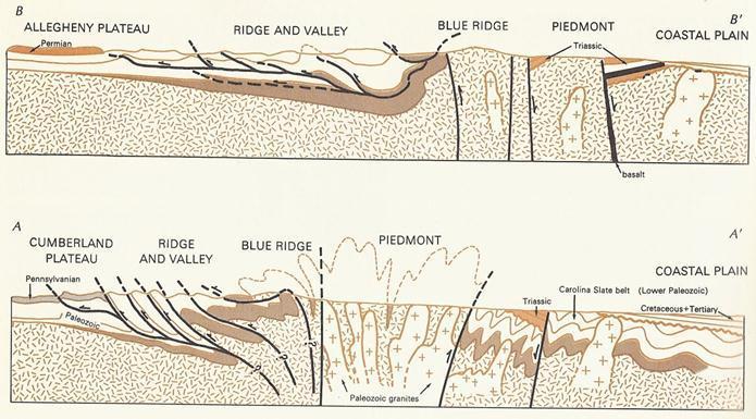
As a final figure, I below provide Figure 14.24 from Dott and Batten, which shows two cross sections across the Appalachian belt. The upper one, B-B’ is from central Ohio, across West Virginia, to the Atlantic Coast near the southern border of Virginia. The lower one, A-A’, is further south, from southeastern Kentucky, eastern Tennessee, across western North Carolina, to the Atlantic Coast of northern Georgia. Note some degree of bilateral structural symmetry across the central Piedmont core of granitic rocks. Also note the interpretation of the western thrust faults as flattening downward so that they involve only the superficial sediment layers.
It is noteworthy that Dott and Batten in the context of this figure comment on the mechanics of thrust faulting and folding, which is so common in the Appalachian region. They state,
At the end of the last century, some European geologists suggested that thrust faulting and much of the associated folding might involve only the weak, superficial sediments and not the more rigid basement. That is, sediments might wrinkle and slide over the basement like a run pushed across a floor. One of the main reasons for such a suggestion was the apparent weakness of the rocks involved in the thrust sheets. How could they be pushed so far? It was suggested instead that all the crumpling was simply caused by large scale sliding of weak strata off an isostatically upwarped basement ridge merely due to gravity.
It is my conviction that catastrophic processes are required to create the elevation gradients needed for gravity sliding of the sediment sheets to occur. Investigation of these fold and thrust belts around the earth therefore appears to me to be a very fruitful research area for creation scientists interested in strengthening the case for the recent global Flood.
Finally, in regard to underlying basis for Blakey’s maps, let me comment that the very same process of synthesizing vast amounts of field observations and associated laboratory analyses to reach the conclusions just described concerning the North Atlantic has been applied by Blakey and others to the rest of the world. Blakey’s maps are the result of that extremely laborious synthesis process. Dott and Batten in the 2nd edition of their book cover much of what was known about the rest of the world as of 35 years ago. The 7th edition is now available, and the authors are now Donald Prothero and Robert Dott, Jr. This might be a reasonable introduction to the geological history of the other continents that has been inferred mostly from their sedimentary rock records.